An Atlas of Hillforts in Britain and Ireland
Funded by AHRC, this four-year collaboration between the Universities of Edinburgh and Oxford will create an online, interactive database of Iron Age hillforts across the Britain and Ireland.

Introduction
Hillforts are one of the most prominent types of prehistoric monument across many parts the British Isles and Ireland as well as being the most obvious legacy of the Iron Age period. Despite fieldwork and changing interpretations of these iconic sites they are still poorly understood in terms of documenting and analysing the variation in characteristics and form across regional and national boundaries.
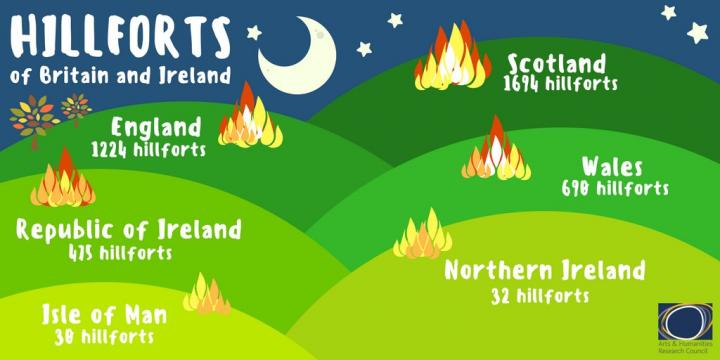
It is likely that there are over 4000 hillforts in Ireland and Britain. Any academic or popular account of later prehistory from c. 1000 BC will include a discussion of hillforts as the dominant monument type: their forms and architecture, possible functions, relationships with their setting and archaeological surroundings. However there is no integrated system that will provide this information on these hillforts, and existing sources of information are diverse, often difficult to access, and hard to integrate to produce wider interpretations, since all previous syntheses have generally been at 'national' (i.e. Ireland, England) scales. Furthermore, most of the ways in which these sites are usually described are based on upstanding examples, but it is now essential to incorporate many ploughed-down remains, only visible as cropmarks, into understandings of these sites.
The Project
This project will create an online interactive database that will include standardised information on all hillforts in the UK and Eire and enable interrogation and analysis at a range of scales from an individual hillfort to the whole collection. The database will be linked to Google Earth/Maps so that the locations of hillforts can be seen within their landscape contexts. The information held will be a compilation of all existing sources, re-structured to provide maximum achievable consistency and the ability to search all hillforts, evaluating and comparing them on meaningful characteristics such as number and configuration of ramparts, ditches and entrances.
In addition the project will produce a paper atlas of hillforts, which will include extensive discussion on the structuring of the data, including consideration of what is and is not a hillfort and why, together with the interpretation of analyses and patterns established at the different scales and visualised through a series of maps and plans. This work will be mirrored by a critical re-assessment of the dating evidence for these sites, including isotopic and other scientific determinations, numismatic and artefactual data, and documentary sources: these monuments are used in both the first millennia BC and AD, and evaluation of the chronological range of these sites at a variety of scales will allow closer readings of patterns through time.
Hillforts are of great interest to a large range of audiences, sometimes just for their intrinsic archaeological value but often as part of wider landscape, historical and environmental interests. Further to encourage the breadth of this participation, the project will include a ‘citizen science’ element that will enable members of the public to participate in the collection of data by visiting and surveying hillforts within a guided framework.
The analysis of this set of sites across the whole of Britain and Ireland - something not previously-attempted - will generate new configurations of information on similarities and differences amongst sites that will challenge prevailing views.
Staff Profiles
Stratford Halliday
Project Website
An Atlas of Hillforts in Britain and Ireland

