About the area
Some background information about the Basentello Valley Survey and San Felice.
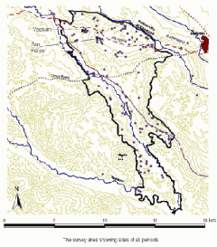
In 1996 an archaeological field survey was begun by a team drawn mainly from the University of Alberta, Canada, in the valley of the Basentello river near Gravina in Puglia, which constitutes in this area the approximate boundary between the Regions of Basilicata and Puglia. From 1998 this was continued by teams drawn largely from the University of Edinburgh. Some 100 square kilometres have now been covered by field walkers walking ca 15m apart, and 161 sites - that is areas of human occupation - have been identified and more intensively surveyed. The survey is diachronic, aimed at tracing the history of settlement and human activity in the area.

The survey has shown that there have been several drastic changes in settlement pattern. There were a few Neolithic and Bronze Age sites, one or two of the Bronze Age ones being fairly large. In the Iron Age there were a few relatively large sites. Most of these continued into the Early Hellenistic period but the number of settlements increased at that time with the establishment of a considerable number of small sites in the open countryside. They were unevenly distributed, the area on either side of the post-medieval drove road being very sparsely settled - which suggests that it was in use also in ancient times and that the economy of this area may have consisted partly in transhumant sheep rearing as it did from the 15th to the early 20th century. The numbers and size of settlements declined markedly from the 3rd century BC. Although there were a few other settlements in Roman times from the 1st to the third century AD to the south and to the extreme north of the area, by far the biggest in the valley was at Vagnari. A large area round it was without habitation and was probably given over to forest and pasture. This area formed the imperial estate of which Vagnari was the centre. In Late Antiquity there was a marked rise in the number of settlements throughout the valley, perhaps caused partly by the division of the estate among tenant farmers. There was another drastic fall in settlement in the Middle Ages. Within the area surveyed there was only one, on the plateau of San Felice. It overlay one of the earlier Iron Age sites and the interest of the plateau has given rise since 2006 to a separate though related project of intensive survey on San Felice, again by teams drawn largely from the University of Edinburgh assisted by some local Italian volunteers.
San Felice
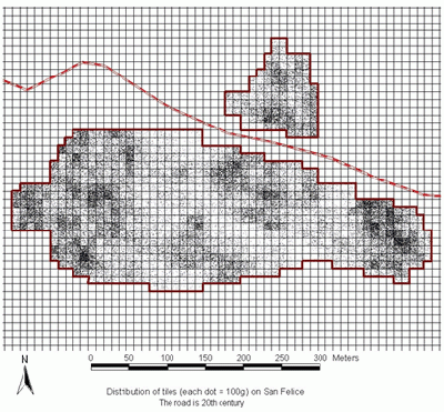
The aim of the project on San Felice was to recover by non-intrusive methods what could be known about the Iron Age site and the medieval one which overlay it. A grid of squares 10m x 10 m covering about 9 hectares was laid out over the top of the plateau; all artefacts within each square were collected or (in the case of tile) noted and the results were mapped using a GIS system (ArcView). This project has now been completed (except for a small resistivity survey which had to be postponed because the soil conditions were unsuitable).

It showed that the Iron Age site began in the Early Iron Age (about the end of the 11th century BC) and came to an end in the course of the 3rd century BC. The tile fall and still more the distribution of storage vessels indicates that there was habitation over the whole plateau but there are clear traces of one road (parallel to and south of the modern one) across the site and other roads parallel and at right angles to it. The distribution of material suggests that in the 4th century BC it was organised as a planned settlement laid out on a grid. The habitation of the plateau began again at the west end in about the 6th century AD. There is further evidence of habitation in the 13th and 14th centuries though whether the site was continuously inhabited throughout the Middle Ages is not clear. It came to an end in the late 14th century AD. The medieval settlement was not large - there is no sign of a castle.
The abandonment of San Felice in the 3rd century BC corresponds roughly to the time of Roman expansion into this area and much of its territory (having degenerated into forest and rough grazing) is likely to have been absorbed in due course into the imperial estate. The revival of habitation in the early Middle Ages took place at the same time as the settlement at Vagnari was declining (the last, small structures at Vagnari are roughly contemporary with the earliest medieval pottery on San Felice) so the history of the two areas was closely linked and they must to some extent be studied together.
Publications
A. Small, C. Small, I. Campbell, M. MacKinnon, T. Prowse and C. Sipe) “Field survey in the Basentello valley on the Basilicata-Puglia border”, Echos du Monde Classique/Classical Views 42, 1998, 337-371.
A.M. Small (2000), "La Basilicata nell'età tardo-antica: ricerche archeologiche nella valle del Basentello e a San Giovanni di Ruoti," in L'Italia meridionale in età tardo antica, Atti del XXXVIII Convegno di Studi sulla Magna Grecia, Taranto, 3 October 1998, Naples 2000, 331-342.
C.M. and A.M. Small (2002), "The Basentello Valley survey (Apulia, Basilicata)", in P. Attema, G.J. Burgers, E. van Joolen, M. van Leusen and B. Mater (eds.), New Developments in Italian Landscape Archaeology. Theory and methodology of field survey; Land evaluation and landscape perception; Pottery production and distribution, Oxford, BAR International Series 1091, 2002, 83?86
C. Small and A. Small, “Archaeological Field Survey at San Felice in Apulia,” Mouseion 51 - ser. III, vol 7, no. 2 (2007), 101-122.

